The AHS cartography collection includes more than 50 maps that chart Altadena’s history, progress and dreams for the future.
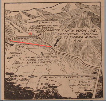 |
| Map from about 1940 shows where New York Ave. cut across Eaton Canyon. (Current road route is indicated by red line.) |
Many are practical representations depicting the distance between places, demarcation of travel routes, and the location of boundaries.
 |
| Realtor’s maps boast plans for future subdivisions. |
Others are whimsical graphic representations publicizing community sites, like businesses and parks. Maps tell darker stories as well, of racism, poverty, and economic downturn. Government tract maps show sub-divided pieces of land.
 |
| Someone has indicated the location of Camp Huntington on this old map. |
Community booster maps, like those issued by the Chamber of Commerce, persuade businesses and future home-owners to put down roots in Altadena. Reading a map is like reading a history book. Best of all, most maps in the AHS collection are indexed for quick reference. Drop in and take a look.